Mucking
A palimpsest of crop marks at Mucking, representing occupation from the Neolithic to Anglo-Saxon period was first recorded on air photography taken by J.K. St Joseph in 1959. The site, which lay on the 100ft river terrace close to the natural crossing point of the Thames was extensively excavated, in advance of gravel extraction, between 1965 and 1978. The sequence of occupation extended back to the Neolithic period which was represented by isolated pits and graves; flints of Mesolithic period were also discovered. A Middle Bronze Age barrow cemetery, with traces of a related field system and other settlement evidence, mostly pits, was also seen. Substantial evidence for occupation did not begin, however, until the later Bronze Age (approximately 9th century BC) when the terrace was dominated by two circular 'mini'-hillforts; the larger being bivallate and 83m across, and the smaller measuring 48m across and overlooking Mucking creek. Most of the round house sites of the Iron Age, lying within penannular eavesdrip gullies, were in open ground which suggested herding. A similar economy was suggested by a complex of frequently renewed curved and rectangular ditches, perhaps providing banks for sheepfolds. Cereal cultivation was also attested by carbonised grain found in storage pits and raised granaries which were represented by rectangular settings of four, six and nine postholes. Prehistoric salt drying and metal working was evidenced by fragmentary crucibles and copper ingots.
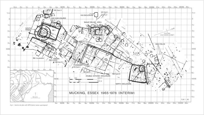
Figure 1: An interim site plan of archaeology at Mucking known from cropmark and excavated evidence.1
Romano-British occupation on the site was basically part of a villa field system incorporating three existing rectangular earthworks;
- from the south, a single entrance paramilitary double ditched enclosure;
- an early farmstead enclosure and
- a late Iron Age earthwork.
 Two Romano-British cemeteries lay within these fields (see EHER 83229 and EHER 13848), and two in the outfield, a probable 4th century stone coffin containing a male burial encased in plaster was also discovered. The domestic buildings of the villa lay outside the cropmark area but their character was indicated by roof and flue tiles, patterned wall daub and window glass found as refuse in ditches and wells. Corn drier flues built of tile, flint and chalk, clay-walled pottery kilns, and timber and flint-lined well shafts were other villa features.
The Anglo-Saxon settlement area had no visible boundaries or strategic earthworks, but was associated with two cemeteries. Military belt fittings from both the settlement and cemetery areas, and weapons from the graves suggested that the first Saxon settlers were soldiers, possibly Germanic mercenaries posted to warn Roman London of suspicious shipping in the Thames estuary. The Saxon settlement which subsequently developed contained the main house type ('grubenhauser'), of which more than 200 examples were discovered. These buildings had sunken floors measuring between 3 and 6m wide by 3 to 8m long but no direct evidence for walls; two gable postholes, however, indicated a pitched roof. The ground level buildings which may have been used partly to house stock were indicated by post holes outlining an area usually of a double square, approximately 12m by 6m. Most of the Saxon settlement dating evidence came from the fills of the sunken huts which included pottery of basically the European Iron Age with several alien characteristics such as 'grass-tempering' of the clay and deliberate roughening or 'schlicking'. Annular loomweights of raw or fired clay and lead and domestic refuse including animal bone, iron pins, shears, knives, bronze brooches, fragments of glass vessels and beads were also discovered. The long sequence of pottery found on the site provided a reference series for south-east England.
Recent features discovered on the site were the cruciform foundations of a Medieval post mill and field ditches. Some of the finds from the site were on display at Thurrock Museum and the British Museum.2
Further references mainly concerned with the details of building construction on this settlement site.3, 4
Additional references. (4-11)
Bibliography
- SEX38153 Clark, A., 1993, Excavations at Mucking Volume 1: Site Atlas. DGO-Digital original. Liverpool University Press. https://doi.org/10.2307/j.ctvxbpj2r.
- SEX75707 Letter Notes and Plan (M V Jones 30 Aug 1979)
- SEX11814 pp.25-26, p.28, pp.30-31, p.40
- SEX76858