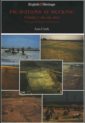
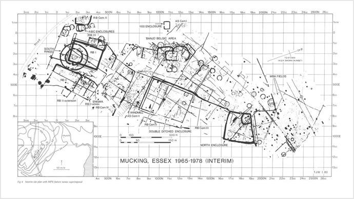
A palimpsest of crop marks at Mucking, representing occupation from the Neolithic to Anglo-Saxon period was first recorded on air photography taken by J.K. St Joseph in 1959. The site, which lay on the 100ft river terrace close to the natural crossing point of the Thames was extensively excavated, in advance of gravel extraction, between 1965 and 1978. The sequence of occupation extended back to the Neolithic period which was represented by isolated pits and graves; flints of Mesolithic period were also discovered. A Middle Bronze Age barrow cemetery, with traces of a related field system and other settlement evidence, mostly pits, was also seen. Substantial evidence for occupation did not begin, however, until the later Bronze Age (approximately 9th century BC) when the terrace was dominated by two circular 'mini'-hillforts; the larger being bivallate and 83m across, and the smaller measuring 48m across and overlooking Mucking creek. Most of the round house sites of the Iron Age, lying within penannular eavesdrip gullies, were in open ground which suggested herding. A similar economy was suggested by a complex of frequently renewed curved and rectangular ditches, perhaps providing banks for sheepfolds. Cereal cultivation was also attested by carbonised grain found in storage pits and raised granaries which were represented by rectangular settings of four, six and nine postholes. Prehistoric salt drying and metal working was evidenced by fragmentary crucibles and copper ingots.  

Figure 1: An interim site plan of archaeology at Mucking known from cropmark and excavated evidence.1

Romano-British occupation on the site was basically part of a villa field system incorporating three existing rectangular earthworks;

  1. from the south, a single entrance paramilitary double ditched enclosure;
  2. an early farmstead enclosure and 
  3. a late Iron Age earthwork.

Two Romano-British cemeteries lay within these fields (see EHER 83229 and EHER 13848), and two in the outfield, a probable 4th century stone coffin containing a male burial encased in plaster was also discovered. The domestic buildings of the villa lay outside the cropmark area but their character was indicated by roof and flue tiles, patterned wall daub and window glass found as refuse in ditches and wells. Corn drier flues built of tile, flint and chalk, clay-walled pottery kilns, and timber and flint-lined well shafts were other villa features.  

The Anglo-Saxon settlement area had no visible boundaries or strategic earthworks, but was associated with two cemeteries. Military belt fittings from both the settlement and cemetery areas, and weapons from the graves suggested that the first Saxon settlers were soldiers, possibly Germanic mercenaries posted to warn Roman London of suspicious shipping in the Thames estuary. The Saxon settlement which subsequently developed contained the main house type ('grubenhauser'), of which more than 200 examples were discovered. These buildings had sunken floors measuring between 3 and 6m wide by 3 to 8m long but no direct evidence for walls; two gable postholes, however, indicated a pitched roof. The ground level buildings which may have been used partly to house stock were indicated by post holes outlining an area usually of a double square, approximately 12m by 6m. Most of the Saxon settlement dating evidence came from the fills of the sunken huts which included pottery of basically the European Iron Age with several alien characteristics such as 'grass-tempering' of the clay and deliberate roughening or 'schlicking'. Annular loomweights of raw or fired clay and lead and domestic refuse including animal bone, iron pins, shears, knives, bronze brooches, fragments of glass vessels and beads were also discovered. The long sequence of pottery found on the site provided a reference series for south-east England.

Recent features discovered on the site were the cruciform foundations of a Medieval post mill and field ditches. Some of the finds from the site were on display at Thurrock Museum and the British Museum.2 

Further references mainly concerned with the details of building construction on this settlement site.3, 4

Additional references. (4-11)

The information in this post was initially compiled by Martyn Barber (RCHME Swindon) and Richard Mead (Ordnance Survey Archaeology Division) for the National Monuments Record (NMR). It has been shared with the Essex HER as part of the NRHE data transfer project.
NRHE UID: 414101
Old NMR Identifier: TQ 68 SE 16

Bibliography
  1.  SEX38153 Clark, A., 1993, Excavations at Mucking Volume 1: Site Atlas. DGO-Digital original. Liverpool University Press. https://doi.org/10.2307/j.ctvxbpj2r. 
  2.  SEX75707 Letter Notes and Plan (M V Jones 30 Aug 1979)
  3.  SEX11814 pp.25-26, p.28, pp.30-31, p.40
  4.  SEX76858 

Essex in the 16th and 17th centuries was the perfect breeding ground for the heightened paranoia of the witch craze. It was a marshy landscape with small, isolated communities, where people lived in extreme poverty, and disease was common. Law and order were upheld by the local landowners of power, but the most serious criminal and civil cases were tried at the Assizes in Chelmsford. Because doctors were too expensive and medical knowledge was scarce, local cunning women were sought out in the most perilous times: childbirth, illness, crop failure or sick livestock. Although cunning women were highly valued in villages, they were also vulnerable to accusations of maleficium, or magic used for evil, when things went wrong. Between 1560 and 1680, 317 women and 23 men were tried for witchcraft in Essex alone, and over 100 were hanged.
Great Waltham

This is exactly what happened to Elizabeth Lowys, a cunning woman who lived in Great Waltham. In 1564, amid rising village tensions, she was brought before both church and civil courts. She was accused by neighbours (and eventually her own husband) of turning her magic against the community, specifically being blamed for the deaths of an infant named Robert Wodley and a child named John Canall. She was ultimately found guilty of "murder by magic" and hanged on Primrose Hill in Chelmsford – the first person to be executed under the Witchcraft Act 1562. The witness depositions are preserved at the Essex's Records office and offer one of the clearest surviving pictures of the community dynamics, rumours, and social tensions that shaped the case against her.

Hatfield Peverel

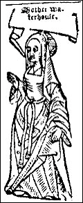
In 1566, three women from Hatfield Peverel were accused of witchcraft: Agnes Waterhouse, Elizabeth Frauncis and Joan Waterhouse. Agnes confessed to having a familiar and was subsequently tried for causing illness and killing both people and livestock. She subsequently became the second person to be executed for witchcraft in England in 1566.

Figure 1: A woodcut of Anges Waterhouse.

Canewdon

Three witchcraft trials occurred here within the short span of ten years. In 1580 the spinster Rose Pye was accused of bewitching to death Johanna Snow, a twelve-month-old child at Scaldhurst Farm. She pleaded not guilty and was acquitted but died in jail probably because she was unable to pay the fee needed to secure her release. In 1585, Cicily Makyn was also charged with practising witchcraft and given five years to mend her ways. In 1590 the ‘Goodwife’ Makins of Canewdon was indicted for witchcraft, as this trial occurs five years after the one involving Cicily Makyn it is safe to assume that they were one and the same, allowing for medieval flexibility with spelling. It appears that Cicily did not heed the warning to reform and as punishment was excommunicated. 

There is a strong folkloric link between witches and the Church of St. Nicholas (EHER 34965) at Canewdon. One saying, recorded in the 19th century, states that so long as the steeple exists, there will always be six witches in Canewdon; and those who walk round the tower at midnight will be forced to dance with the witches. According to a later addition, when a village witch died, a stone always fell from the church wall (or vice versa – “every time a stone falls from the tower, one witch will die, and another will take her place”. Running seven times around a certain grave in the graveyard would also have supernatural consequence, making either witches or the Devil appear. 

There is another local legend saying the crossroads where Anchor Lane, Scotts Hall Road, Lark Hill Road and the lane to the church meet is where a witch was buried, with a stake through her heart. Crossroads have been linked to the supernatural since at least the Anglo Saxons, seen as liminal spaces (spaces between worlds); and criminals and suicides were often hanged or buried there as punishment. Another example is north-east of the village of Finchingfield, on a grassy triangle where the roads to Finchingfield, Stambourne and Wethersfield meet.

A patch beside the river Crouch in the north of Canewdon parish has long been known as the ‘Witch’s Field’. A witch was said to have been buried there after drowning, and for long afterward it was thought no crop would succeed in growing there.

There was one person said to be more powerful than the witches of Canewdon - James Murrell, the cunning man of Hadleigh. 

St Osyth

Ursula Kemp of St Osyth was another cunning woman who was accused of (and apparently confessed to) witchcraft in 1581; this time using familiars to kill and bring sickness to her neighbours. They consisted of two tomcats (Jack, a black cat and Tyttey, a grey cat), a female toad (Pigine), and a female lamb (Tyffin). They were divided by gender, with the males used to plague people to death and the females used to cause bodily harm. According to local legend, she was kept in The Cage of St Osyth, before being tried in Chelmsford. Even while imprisoned for her alleged crimes, members of the community continued to seek advice form Ursula. While she was being tried, she was misled to think that implicating other women would lead to her freedom. This meant that this became one of the largest early mass accusations in England, detailed in contemporary pamphlets. A skeleton found on Mill street in 1921 was theorised to be Kemp’s but it was found to be a man in 2011 (EHER 16178).

Felsted

Boote House (EHER 37046), built by George Boote in 1596 in the centre of Felsted, is a historic building featuring carved wooden brackets supporting its overhanging first floor. The most distinctive bracket depicts the Felsted Hag, a grotesque female figure with cloven hooves, traditionally believed to ward off evil. While local legend claims she represents Boote’s cursed wife, another modern tale says she comes to life on Halloween and walks the village streets.

Manningtree and Mistley
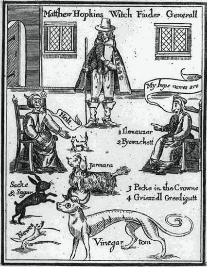
Figure 2: Frontispiece from Matthew Hopkins's The Discovery of Witches (1647), showing witches identifying their familiar spirits.

According to local legend, in 1644 Hopkins turned up in the town to buy the Thorn Inn in Mistley (EHER 34660) with money he had inherited from his late father, a puritan preacher by the name of John Hopkins. It was in Manningtree that Hopkins met John Stearne, who first accused a group of Manningtree women of witchcraft. Hopkins became his assistant and set out to find evidence, alleging to overhear women discussing their meetings with the Devil in March 1644. This started his short but vicious career as a witchfinder. In their fourteen months on the road, it is estimated Hopkins and Stearne were responsible for the deaths of between two and three hundred people - more than all the other witch-hunters in England of the previous 160 years.

Utilising the chaos of the Civil War, Hopkins and Stearne concocted their titles and credentials, and falsely claimed to have been appointed by Long Parliament to uncover and prosecute witches across East Anglia, charging extortionate fees to do so. He jailed and interrogated those he believed to be witches at Colchester Castle, where many are believed to have died as a result of their incarceration before even being brought to court. Although torture was nominally unlawful in England, Hopkins subjected the accused women to sleep deprivation and employed the services of ‘seekers’ - women who would search the accused's' bodies for what was known as the ‘Devil’s Mark’. If the suspected witch had no such visible marks invisible ones could be discovered by pricking. Therefore, ‘witch prickers’ were employed, who pricked the accused with knives and special needles looking for such marks, normally after the suspect had been shaved of all body hair. He would also cut the arm of the accused with a blunt knife, and if she did not bleed, she was said to be a witch. He would also employ methods such as the famous swimming test: suspects were tied to a chair and thrown into water: all those who ‘swam’ (floated) were considered to be witches; based on the idea that as witches had renounced their baptism, water would reject them. Standing on the little humpback of the Hopping Bridge (EHER 34676), you can look over at the still waters of the same pond that Hopkins used to test the witches of Mistley and Manningtree, and his ghost is said to haunt there. Even at the height of the witch craze, this ordeal was seen as too cruel and irrational, and Hopkins and Stearne were forced to discontinue by judicial authorities in 1645. Ducking stools are said to survive at Cage End, Hatfield Broad Oak (EHER 18754), Coggeshall (EHER 18442), Epping (EHER 18475) and Hutton (EHER 19122).  

This was the start of the tide shifting against the witchfinders. John Gaule, vicar of Great Staughton in Huntingdonshire, objected to the methods the men used and began openly preaching against them in his sermons, and published a letter exposing their methods. This led to their official questioning during the spring of 1647 at the Norfolk Assizes in Norwich. Faced with mounting public resentment over his controversial methods and extortionate fees, as well as his own rapidly declining health, Hopkins disbanded his team and retired to Manningtree. Before his death in August 1647, he published his book The Discovery of Witches in May 1647, ensuring his legacy. He was buried at Church of St Mary at Mistley Heath (EHER 34662). Following the publication of Hopkins's book, his practices were incorporated into law books as official recommendations and became the catalyst for the first witch hunt in the New England colonies (1648-1663) and the Salem Witch Trials (1692-1693).

Bibliography

  • Cabell, Craig (2006), Witchfinder General: The Biography of Matthew Hopkins, Sutton Publishing, ISBN 978-0-7509-4269-0
  • Edwards, K.A. (2010), Witchcraft in Tudor England and Scotland. In A Companion to Tudor Literature, K. Cartwright (Ed.). https://doi.org/10.1002/9781444317213.ch2
  • Gaskill, Malcolm (2005), Witchfinders: A Seventeenth-Century English Tragedy, John Murray, ISBN 978-0-7195-6120-7
  • Notestein, Wallace (1911), A History of Witchcraft In England from 1558 to 1718, American Historical Association 1911 (reissued 1965) New York Russell & Russell, ISBN 978-1169793521
  • Russell, Jeffrey B (1981), A History of Witchcraft, Thames & Hudson, ISBN 978-1-55553-165-2

Links

What is a Thames sailing barge?

Thames barges were flat-bottomed sailing boats that were commonly used for shipping cargo along the River Thames and surrounding Essex coasts. More specifically referred to as a spritsail-type barge, Thames sailing barges are known for their large red sails which give them their iconic silhouette. During the post-medieval period, many Thames sailing barges were built at Maldon, the iconic silhouette now inspiring Maldon District Council’s logo. With the Industrial Revolution bringing new developments in the shipping and sailing industries, many barges were converted to motorised vessels in the late 19th and early 20th centuries. Other vessels were repurposed for local ventures, some being converted as yachts or houseboats, and by the mid to late 20th century many became abandoned and hulked along the Essex coastlines, no longer useful to their owners for commercial cargo transport.

Thames barges in the Essex HER and wider maritime context

The Essex HER (EHER) holds information for more than 300 ‘maritime’ records, with the greatest concentrations in Tendring along the River Stour and at the international port of Harwich, and in Rochford along the River Blackwater and the east coast at Foulness and Maplin Sands. Some of the records document the last known location of shipwrecks, whilst others record known information about hulked vessels that are no longer capable of sailing as a result of conversion for storage purposes or deliberate abandonment. Records for maritime vessels which are situated below the Mean High Water are maintained by the National Marine Heritage Record.

There are records for at least 16 Thames sailing barges in the EHER, though the true number of wrecked or hulked Thames barges in Essex is likely far greater, owing to the fact that, for many vessels, the identification information is no longer accessible or may not have been known when the wreck was recorded. Other classes of vessel recorded in the maritime monument records include yachts, cutters, brigs, schooners and target barges, as at the 1930s bombing range in Bradwell-on-Sea (EHER 46141).

The Rose at Beaumont Quay, Hamford Waters

A notable example of the Thames Sailing Barge is The Rose (EHER 81766), the remains of which are hulked at Beaumont Quay in Hamford Waters (see EHER 9121). Together with the remains of the early 19th century Beaumont Cut (an artificial canal, EHER 83447) and a late 19th century lime kiln (EHER 81767), the site is designated as a Scheduled Ancient Monument.

Notable for her documented history and unlikely abandonment, The Rose (official no. 82392), was a 42-ton spritsail barge, launched on 29th September 1880 and built in Maldon, an early medieval harbour and focal point for post-medieval ship building. When launched, she was owned jointly by Charles Ward, a miller, and Charles Hawes and Samuel Thompson, hay merchants of Maldon. Presumably she carried cargoes of hay or grain products between Maldon and London prior to being sold to new owners in around 1930 and becoming a lighter at Heybridge Basin. In 1961 she was retired from coastal trade and sold for conversion to a house barge. It was at this time that she came to be towed into position at Beaumont Quay, where she has remained ever since, the conversion never taking place.

Although it appears as though The Rose wasn’t ever based at the Beaumont Quay for coastal trade, another barge, the Beaumont Belle of Maldon (EHER 13733), was. Built in 1894 at Maldon by The Rose’s ship builder John Howard, the Beaumont Belle (official no. 102894) was a 54-ton spritsail barge. From 1947 she was sold for use as a lighter and in the 1990s she was hulked and burnt at Heybridge Creek.

Maldon shipbuilding legacy and the barge graveyard

Maldon can trace its origins as a coastal port town well into the Early Medieval period. Documentary evidence from around 1066 indicates that, as well as a quay and presumed loading/unloading and storage facilities, the Hythe may have also had a boat-building yard at this time (see EHER 7717). The Hythe continued to be the focal point of maritime activity in Maldon into the medieval period, with associated industry, such as shops and warehouses, developing around the waterfront.

By the post-medieval period, coastal trade from the port was so plentiful that a second harbour area at Fullbridge (EHER 18800) was created, redirecting the focus to further up the River Blackwater. During this time, the Hythe appears to have retained its role as a boat-building yard, as is evidenced by the listed workshop (EHER 38472) of Taylor and Sons, Sailmakers, which had originally been built as a granary. A similar weatherboarded single storey building, probably 20th century in origin, survives at the southern extent of the Hythe and is also used for boat repair purposes. In the modern day, the Hythe is now home to many Thames sailing barges that have been lovingly restored and offer regular day trips on the Blackwater.

Roughly 1km to the south-east near the Maldon Promenade Park is a collection of hulked Thames barges and other vessels, locally known as the ‘Maldon Barge Graveyard’ (EHER 82000). The site consists of approximately 15 hulked barges and boats including the British Lion of Rochester (EHER 13735); Mamgu of London (EHER 13739); William Cleverly of Rochester (EHER 13744); Pretoria of Faversham (EHER 13741) and Vicuna of London (EHER 82001). Amongst the hulks are also the remains of a lighter, a steel mooring pontoon, an Admiralty launch, two fishing boats and several other vessels.

Use the links to explore the EHER monument records for the individual vessels in the Maldon Barge Graveyard.

Introduction

Essex contains one of the largest concentrations of recorded medieval moated sites in all of England, with estimates of well over 900 examples scattered throughout the county's historic landscape. Most of these moats (built largely between 1250 and 1350) served as high-status or prestigious domestic residences for lords, manorial tenants, and prosperous farmers rather than functional military defences.

Distribution

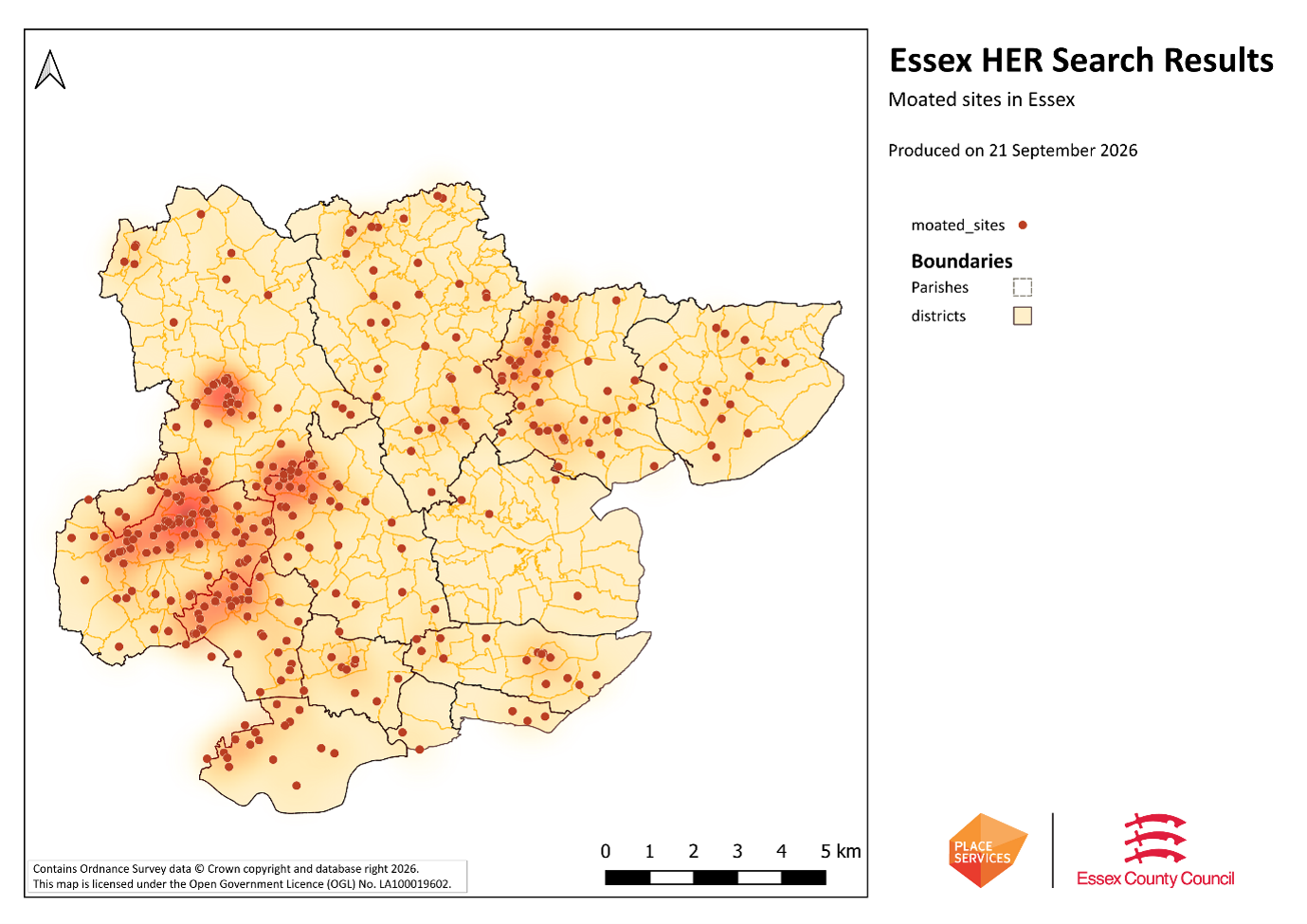
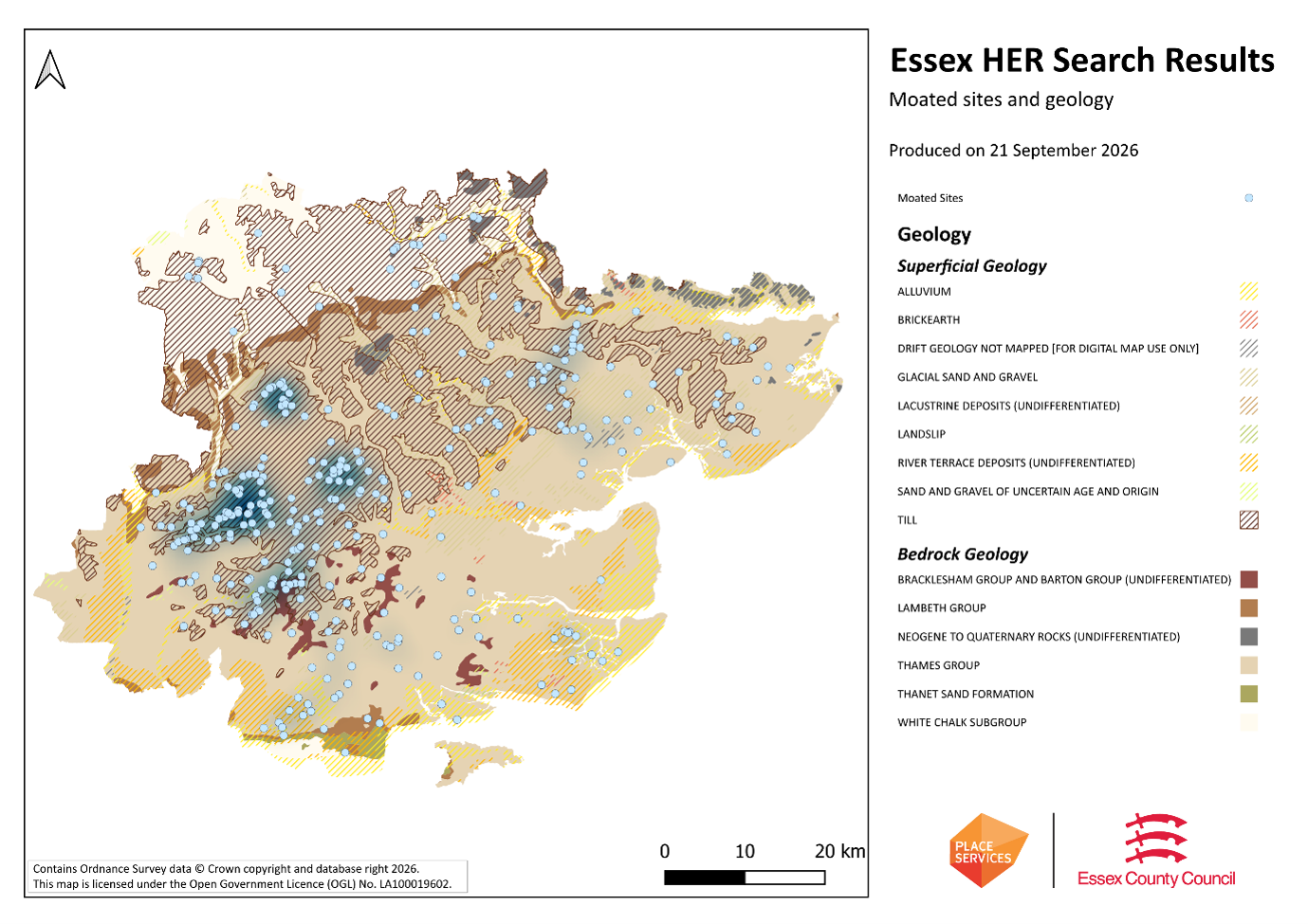
Around 6,000 moated sites are known in England, therefore Essex makes up around 15% of the known sites across the country. Most of these are located in the western part of the county (see distribution map), where clayey, tillable soil has meant both denser settlement activity and more water retention.

Significance

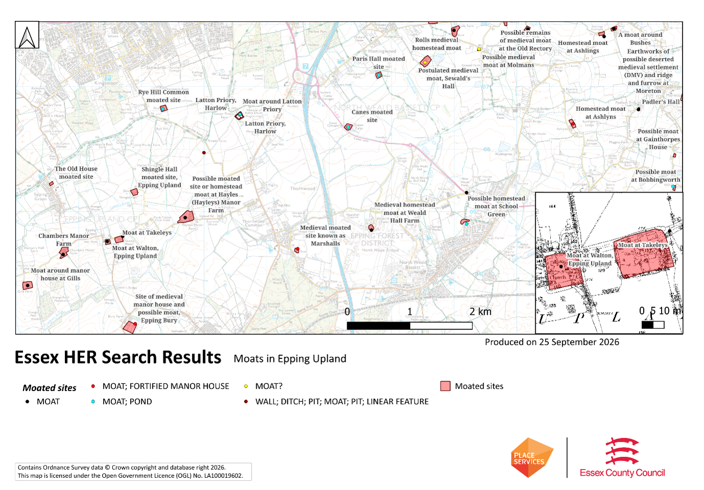
Most moated sites served as prestigious aristocratic and seigneurial residences with the provision of a moat intended as a status symbol rather than a practical military defence. For example, the moat at Takeleys (EHER 3728) was around a manor house; meanwhile the moat at Walton (EHER 3825) to its immediate west was originally around a vicarage. The peak period during which moated sites were built was between about 1250 and 1350 - however, moated sites were built throughout the medieval period. They form a significant class of medieval monument and are important for the understanding of the distribution of wealth and status in the countryside. Many examples provide conditions favourable to the survival of organic remains and environmental evidence, helping us understand the medieval landscape and the economy of its inhabitants. They dominate the landscape of rural Essex, and serve as a reminder of the medieval period.

Appearance

How can one recognise a moated site, as they exhibit a high level of diversity in their forms and sizes? Usually, the first step is to look at earthwork evidence, either from earthwork surveys or LiDAR evidence. They usually have a singular wide, rectangular or sub-rectangular ditch, often or seasonally water-filled, partly or completely enclosing one or more islands of dry ground; on which stood domestic or religious buildings (around 40m-100m across on average). In some cases, the islands were used for horticulture. One can verify them via documentary evidence, for example using historic Ordnance Survey mapping (which often has them labelled as ‘moat’), or local historical monographs that mention significant manors in the area. Many were converted to ponds (see map) or left dry in the modern period.

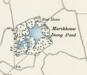
Situated on the Tillingham Marshes at the eastern end of the Dengie Peninsula is an unusual and important historic monument. When viewed from the nearby footpath, the location of the monument is marked by a small and dense forest. But the forest hides a star-shaped pond, which begins to reveal itself on the modern Ordnance Survey (OS) map. It’s true extent is best represented on the historic OS map, which illustrates the six original ‘arms’ that fan out from the centre of the pond and curve around the feature in a clockwise direction.

The pond is Marsh House Decoy (EHER 37), an 18th century decoy pond used to catch wildfowl (ducks), and a Scheduled Ancient Monument. It is one of 48 ponds of this type recorded by the EHER, and one of 30 that are known in Maldon District alone. 

What is a decoy pond?

Decoy ponds are thought to date from the medieval period. They may have originated in their current form from Holland and were introduced to England in the 17th century. Historic England describes decoy ponds as:

“…artificially created or modified pools of water onto which wildfowl were lured to be trapped and killed for food and for feathers. They consist of a central pool off which lead a number of curving arms or ditches, known as pipes. Nets were constructed over the narrowing ends of these pipes towards which the birds were lured by the decoyman and his dog.” 1

What makes Marsh House decoy special?

Marsh House decoy is a well-preserved example of a decoy pond and, unlike many other ponds in Essex, the documentary evidence for the yearly ‘takings’ of the pond survives similarly well. The documents describe the types of duck caught, how much profit was made each year, and the names of the decoyman, tenants and landowners from 1795 onwards (including the Rev. Sir Henry Bate Dudley as tenant in 1797). It is therefore one of the most well-documented decoy ponds in the county. From these documents we can learn that the number of birds caught was far greater in the earlier period of its use than in later days. For example, an article in the Essex Naturalist (the Journal of the Essex Field Club) records:

“…10,000 Wigeon, Teal and Wild Duck were taken in 1799; from 1852-53 to 1856-57 a total of 11,041, averaging 2,208 per annum, was taken… from 1859-60 to 1864-65 the average annual catch was 3,500, then dropped to about 2,500 and about 1890 the numbers had fallen to about 2,000.” 2

There appears to have been a working relationship between this and the neighbouring Grange Decoy (EHER 2066), approximately 1.5km to the north. One pond would keep the lead in the number of Wigeon taken for several seasons and then the other would have its turn. Sometimes the ducks might desert one altogether in favour of the other.

Marsh House Decoy is also known to have continued in use into the early 20th century, further adding to its significance. It experienced a short break in use during the First World War and was still in use in 1943 when Glegg wrote the Essex Naturalist article. Also unique to Marsh House Decoy is the survival of the associated decoyman’s hut, which is included in the Scheduling.

Decoy ponds in Maldon and beyond

The Marsh House and Grange decoys are among 12 known decoy ponds on the Dengie Peninsula. The greatest concentration of decoy ponds in Essex is found along the northern bank of the River Blackwater from Heybridge to Tollesbury, where the EHER records 18 monuments (including one on Northey Island, EHER 7956). The marshy areas of the Tendring coast are also a common location for the ponds, with a further 14 records in this district. The most inland record is for the possible site of ‘Felstead Decoy’ (EHER 82225) which is situated near Leighs Priory in Felsted, Uttlesford. There are five Scheduled decoy ponds in the Essex HER (EHER 37, EHER 9996, EHER 11560, EHER 16282, EHER 16881). 

To explore the records for decoy ponds in Essex, use the Advanced Search to refine by monument type ‘decoy pond’. Or follow this link.

Bibliography

  1. Decoypond 700m north east of Marsh House Farm, Tillingham - 1013835 | HistoricEngland
  2. Glegg, W., 1943-1944, The Duck Decoys of Essex, in Essex Naturalist XXVII, p.194